Earth Observation Data Management System (EODMS)
What is EODMS?
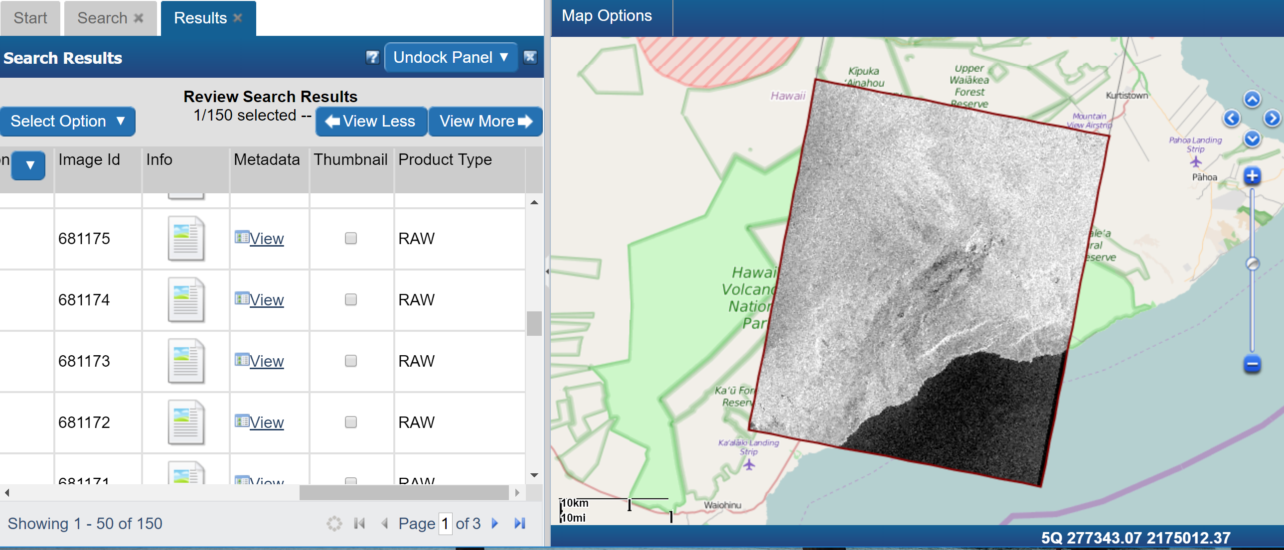
The Earth Observation Data Management System (EODMS) is a geospatial platform provided by Natural Resources Canada (NRCan) open to the general public to discover and download authoritative Canadian Earth Observation (EO) raster data. Check out our EODMS How-To Guide and our Prezi. The site is located at https://www.eodms-sgdot.nrcan-rncan.gc.ca/index_en.jsp.
History
With the second largest landmass on earth and the longest coastline in the world, Canada relies on satellite technology to monitor its land and borders. Providing access to this technology is a core mandate of NRCan's Canada Centre for Mapping and Earth Observation (CCMEO). Through partnerships across government, strong links to academia and the private sector, including international collaborations, CCMEO ensures that satellite data is available to serve the needs of the Canadian Government and all Canadians. Since 1971, CCMEO has accumulated an EO data archive in excess of 2 PB. This data originated from many satellites and airborne sensors. The 2012 Canadian Federal Budget included NRCan’s revitalization plan which sought to improve Canada’s EO satellite capacity and access to this data. This plan was realised through the purchase and installation of four (4) new satellite antennas as well as the brand new Earth Observation Data Management System which replaced several legacy systems.
Services
Today, CCMEO delivers several EO data services in support of the Government of Canada’s (GC) priorities on the economic development of natural resources, the North, safety, security, sovereignty, and environmental monitoring.
EODMS
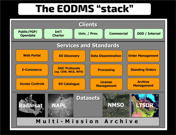
Data services delivered by EODMS include:
GENERAL PUBLIC SEARCH AND DOWNLOAD
- RAW RADARSAT-1, RAW RADARSAT-2. The discovery and download of RADARSAT-1 Open Data Products as well as Thematic Data Sets,
- National Air Photo Library (NAPL)
- NOTE: In November 2020, the Ring of Fire region of Ontario was made free for digital download.
- RCM. Registered public users will be able to download GRD and GCD products which are limited to the following regions and resolutions only: Canada Land - coarser than or equal to 16 m. and World Maritime - coarser than or equal to 100 m. Products over World Land excluding Canada will not be available. The scene has to be completely within Canadian Land. This includes inland water (e.g. Great Lakes in Canada), but excludes and must not contain / overlap at all with coastline (inc. Arctic) waters and St-Lawrence river. Checkout our Canada Landmass Map Boundary Google Map
GC ONLY SEARCH AND DOWNLOAD
- NMSO CSI: COSMO-SKYMED, Disaster Monitoring Constellation, Gaofen-1, GeoEye-1, IKONOS, Indian Remote Sensing, NOAA, PlanetScope, QuickBird-2, RADARSAT-2 Products, RapidEye, SPOT, TERRASAR-X, WorldView-1, WorldView-2, WorldView-3, WorldView-4
- HTTPS/FTP download-only of *all ordered NMSO CSI* that are not yet map-searchable: Deimos-2, Flock1-SSO, GF-1, KOMPSAT-3, TanDEM-X, Terra, Terra/Aqua For these missions, we invite users to check out this article Text-Searching EODMS Server with Filezilla
- RADARSAT 2 (R2) Products.
MULTI-MISSION ARCHIVE (MMA)
The storage backbone of EODMS is CCMEO’s Multi-Mission Archive (MMA) which is the Canadian authorized repository of over 3PB of RADARSAT-1, RADARSAT-2, RCM, NAPL and NMSO commercial imagery. The capacity of the archive is currently 5 PB and growing. The data is stored robustly using redundant storage and securely to comply with the Remote Sensing Space Systems Act
COPERNICUS CANADIAN RELAY
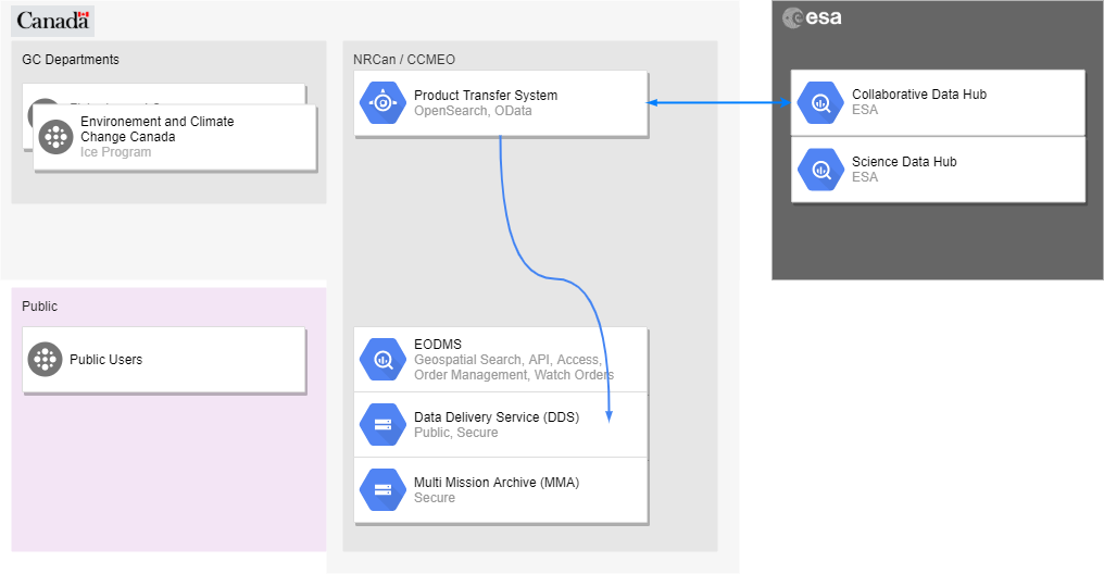
In 2015, Canada joined the Sentinel collaborative ground segment to facilitate Near-realtime (NRT) access to Sentinel satellite data. CCMEO retrieves data from the Copernicus Collaborative Hub over a high speed science network and stages it on a Canadian relay site with reliable download speeds for Canadian users.
CCMEO provides this service using a Product Transfer System (PTS) to pull SENTINEL products from the NRT Collaborative hubs and then stages the data on EODMS with a life of 14 days with dependable download speeds. While this limited access has operationalized the use of SENTINEL data to key GC programs, open NRT access to SENTINEL-1,2,3,5p is being considered. Please contact us for more info: mailto:nrcan.eodms-sgdot.rncan@canada.ca
Government/Special Access: RCM, RADARSAT-2, NMSO
RADARSAT CONSTELLATION MISSION (RCM)
For FREE GC/VETTED ACCESS to RCM:
- Create an EODMS account
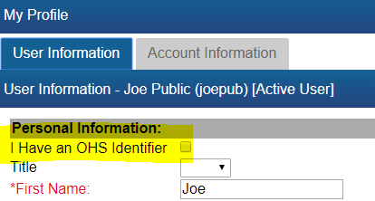
- Check the "I have an OHS Identifier" checkbox in your profile.
- Submit your application:
- For CANADIAN PROVINCES, TERRITORIES and INDUSTRY, please submit an application to How to become a user.
- For GOVERNMENT of CANADA users submit your EODMS username to the Canadian Space Agency in an email to asc.r-sat.csa@canada.ca
- Finally, you will receive an email when your EODMS account is ready.
NOTE: Ensure the ORGANIZATION NAME you specify on your VETTING APPLICATION exactly matches the organization name entered in your EODMS ACCOUNT registration
RADARSAT-2
For free GC access to RCM:
- Create an EODMS account
- Provide you username to the Canadian Space Agency at asc.r-sat.csa@canada.ca
CSA R-2 Project Programs
Did you know that CSA coordinates several [RADARSAT-2 special access programs] to encourage the use of space data. Also available is access for the The International Charter: Space and Major Disasters. Find out more here.
NMSO-CSI
The NMSO-CSI is a GC initiative to cut down on the procurement of duplicate commercial satellite imagery across the public service. All departments with commercial satellite imagery needs should route all procurement through NMSO E60SQ-120001 after which imagery will be loaded on to EODMS to be re-used by the whole of government. All GC employees can have free access to NMSO Commercial Satellite Imagery (CSI) already purchased by the GC. Simply create an EODMS account and then send a request to your Department NMSO point of contact (PoC) for your added privileges using the form on our GCPedia (Government-only) page, EODMS Account Approvals for Government and Special Access
Current NMSO CSI Offerers
Current NMSO CSI Agreement
License Details
- APPENDIX E TO ANNEX A - Designated Government FTP/SFTP directory path to deliver Product Delivery Package
The Offeror must use the Designated Government FTP directory structure to deliver the Product Delivery Package. From the Offeror FTP/SFTP account, the delivery directory path is defined as follow: /<dept>/<satellite>/<sensor>, where <dept> : correspond to the government department name of the Identified User (available on the Call-Up) as described in Table E.1, <satellite> is satellite name (to be defined at issuance of NMSO), <sensor> is sensor name (to be defined at issuance of NMSO),
| License Level | License Level Description |
|---|---|
| Level A | The project level, at which a License Class allows Identified Users to only share the data with the designated sharing entities identified in Table A, “License Class Designations”, more specifically “Included Entities” on a project basis; and |
| Level B | The broad level, at which a License Class allows Identified Users to share the data with all users of the designated sharing entities identified in Table A “License Class Designations”, more specifically “Included Entities”. |
| License Class | Included Entities |
| Base/Class 0 | Canadian Government Departments, Agencies, and Crown Corporations |
| Class 1 (A, B) | Base + Canadian Academic Research community affiliated with a recognized University or College |
| Class 2 (A, B) | Base + Provincial and Territorial Governments in Canada |
| Class 3 (A, B) | Class 2 + Local (Municipal, Aboriginal People - First Nations, Inuit, Metis or Tribal Councils) Governments in Canada. Local Governments would include two cities with over 500,000 in population and up to 20 municipalities with less than 500,000 in population |
| Class 4 (A, B) | Base + Local Governments (Municipal, Aboriginal People - First Nations, Inuit, Metis or Tribal Councils) in Canada. Local Governments would include two cities with over 500,000 in population and up to 20 municipalities with less than 500,000 in population |
| Class 5 (A, B) | Civilian Departments of the Government of Canada and their international counterparts as per their mandates. (Example: Canadian Ice Service and US National Ice Center and International Ice Patrol under the North American Ice Service [NAIS]) |
| Class 6 (A, B) | Base + USA Government Agencies (Military and Civilian) e.g. US Department of Defense |
| Class 7 (A, B) | Base + Military Partners (USA, UK, AUS, New Zealand) |
| Class 8 (A, B) | Base + Military Partners (USA, UK, AUS, New Zealand) + 28 NATO Member Countries (See http://www.nato.int/pfp/eapc-cnt.htm.) |
| Class 9 (A, B) | Base + Military Partners (USA, UK, AUS, New Zealand) + 28 NATO Member Countries (See http://www.nato.int/pfp/eapc-cnt.htm .) + any of 21 NATO Partners for Peace
(See http://www.nato.int/pfp/sig-cntr.htm .) |
| Class 10 | Note: Class 10 is replaced by Class 12 below |
| Class 11 | Base + public at large (i.e. Public Good License Class) |
| Class 12 (A, B) | Base + Military and Defence related organizations of foreign countries with which Canada is involved in international duties (example: United Arab Emirates forces in Afghanistan). The list of foreign countries will vary depending on the operations involved. The list of countries will be provided to the Offeror for country list approval prior to sharing. An addendum to the license shall list the countries approved for sharing. |


