Important: The GCConnex decommission will not affect GCCollab or GCWiki. Thank you and happy collaborating!
Difference between revisions of "Earth Observation Data Management System (EODMS)"
| Line 36: | Line 36: | ||
=== NMSO === | === NMSO === | ||
| − | Did you know that all Government of Canada (GoC) employees can have free access to NMSO Commercial Satellite Imagery (CSI) already purchased by the GoC available on EODMS? You need only send an account request to your Department NMSO point of contact (PoC) for your account approval. You can find the request form and your PoC on our GCPedia (Government-only) page, [http://www.gcpedia.gc.ca/wiki/Earth_Observation_Data_Management_System_(EODMS)#Account_Approvals_for_Government_and_Special_Access EODMS Account Approvals for Government and Special Access] | + | Did you know that all Government of Canada (GoC) employees can have free access to NMSO Commercial Satellite Imagery (CSI) already purchased by the GoC available on EODMS? You need only send an account request to your Department NMSO point of contact (PoC) for your account approval. You can find more information on our [[EODMS_NMSO]] page as well as the request form and your PoC on our GCPedia (Government-only) page, [http://www.gcpedia.gc.ca/wiki/Earth_Observation_Data_Management_System_(EODMS)#Account_Approvals_for_Government_and_Special_Access EODMS Account Approvals for Government and Special Access] |
=== RADARSAT === | === RADARSAT === | ||
| Line 92: | Line 92: | ||
=== OCPN === | === OCPN === | ||
| − | Saviez-vous que tous les employés du gouvernement du Canada (GC) peuvent avoir un accès gratuit aux images satellitaires commerciales (ISC) de l'OCPN déjà achetées par le GC disponibles sur le SGEDO? Vous devez uniquement envoyer une demande de compte à votre point de contact OCNP pour approuver votre compte. Vous pouvez trouver le formulaire de demande et votre PoC sur notre page GCPedia (réservée au gouvernement), à l'adresse http://www.gcpedia.gc.ca/wiki/Earth_Observation_Data_Management_System_(EODMS)#Account_Approvals_for_Government_and_Special_Access Approbation de compte EODMS pour le gouvernement et l'accès spécial] | + | Saviez-vous que tous les employés du gouvernement du Canada (GC) peuvent avoir un accès gratuit aux images satellitaires commerciales (ISC) de l'OCPN déjà achetées par le GC disponibles sur le SGEDO? Vous devez uniquement envoyer une demande de compte à votre point de contact OCNP pour approuver votre compte. Vous pouvez trouver plus d'informations sur notre page [[EODMS_NMSO]], ainsi que sur le formulaire de demande et votre PoC sur notre page GCPedia (réservée au gouvernement), à l'adresse http://www.gcpedia.gc.ca/wiki/Earth_Observation_Data_Management_System_(EODMS)#Account_Approvals_for_Government_and_Special_Access Approbation de compte EODMS pour le gouvernement et l'accès spécial] |
=== RADARSAT === | === RADARSAT === | ||
Revision as of 10:22, 25 February 2019
What is EODMS?[edit | edit source]
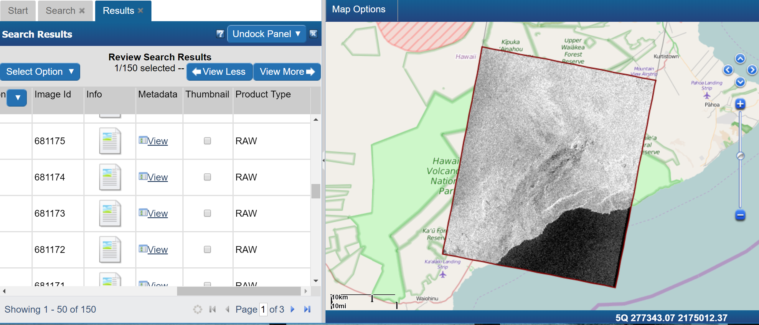
The Earth Observation Data Management System (EODMS) is a fully integrated geospatial platform provided by NRCan/RNCan to the general public to discover and access authoritative Earth Observation (EO) data.
The site is located at https://www.eodms-sgdot.nrcan-rncan.gc.ca/index_en.jsp
History[edit | edit source]
With the second largest landmass on earth and the longest coastline in the world, Canada relies on satellite technology to monitor its land and borders. Providing access to this technology is a core mandate of NRCan's Canada Centre for Mapping and Earth Observation (CCMEO). CCMEO is the Government of Canada’s Centre of Expertise for remote sensing and geodesy. Through partnerships with government stakeholders, strong links to academia and the private sector, including international collaborations, CCMEO ensures that satellite data is available to serve the needs of the Canadian Government and Canadians. Since 1971, CCMEO has accumulated an archive in excess of 1 PB of Earth Observation (EO) data. This data originated from various satellites and airborne sensors. The 2012 Canadian Federal Budget included NRCan’s revitalization plan which sought to maintain and improve Canada’s EO satellite capacity and access to this data. This plan was realised through the purchase and installation of four (4) new antennas as well as the brand new Earth Observation Data Management System which replaced several legacy systems.
Services[edit | edit source]
Today, CCMEO delivers several EO data services in support the Government of Canada’s priorities on the economic development of natural resources, the North, safety, security, sovereignty, and environmental monitoring.
EODMS[edit | edit source]
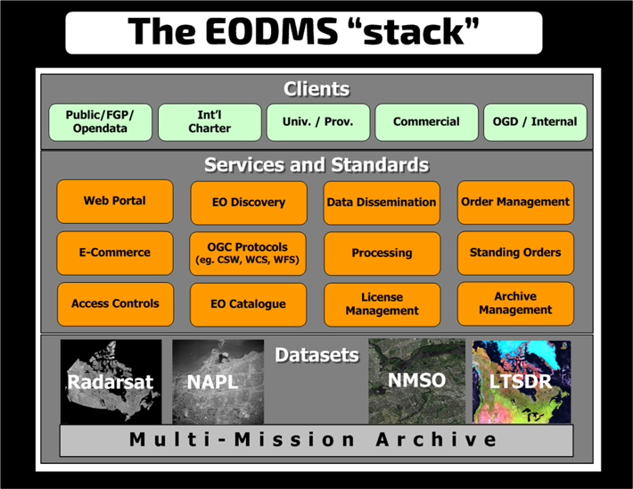
Data services are delivered through the Earth Observation Data Management System (EODMS) and include:
- The user-access-controlled discovery and ordering of product from RADARSAT 1,2 (R1, R1), RADARSAT Constellation Mission (RCM), and commercial imagery procured through the NMSO (i.e. COSMOS-Skymed, Deimos-2, DMC, EROS-B, Flock1-ISS, Flock1-SSO, GeoEye-1, GF-1, GHGSat-D, IKONOS, IRS1C-LISS3, IRS1C-PAN, IRS1C-WiFS, IRS1D-LISS3, IRS1D-PAN, IRS1D-WiFS, IRSP6-AWiFS, IRSP6-LISS3, IRSP6-LISS4, KOMPSAT-2, KOMPSAT-3, KOMPSAT-5, PLEIADES, QuickBird-2, RapidEye, SPOT-4, SPOT-5, SPOT-6, SPOT-7, TanDEM-X, Terra, Terra/Aqua, TerraSAR-X, WorldView-1, WorldView-2, WorldView-3, WorldView-4, ZY-3).
- The generic public discovery of raw R1/R2/RCM data.
- The discovery and ordering of Canada Centre for Remote Sensing (CCRS) Thematic Data Sets, and the National Air Photo Library
- EODMS is also fully OGC compliant having implemented several standards such as Web Map Tile Service (WMTS), Web Coverage Service (WCS), Catalog Services for the Web (CSW) to name a few. EODMS also implements several geospatial ISO standards including ISO 19115 and ISO 19139.
Multi-Mission Archive (MMA)[edit | edit source]
The backbone of EODMS is CCMEO’s Multi-Mission Archive (MMA) which is the authoritative repository for raw Canadian Earth Observation data in Canada. CCMEO has approximately 1PB of EO Data of which the main holdings are RADARSAT-1, RADARSAT-2, and NMSO commercial imagery. The MMA will also house all RCM data received in Canada (i.e. all data received at CCMEO as well as DND’s Polar Epsilon stations). The current capacity of the archive is currently 3 PB and will grow by 1 PB each year. The data is stored robustly using redundant storage and securely to comply with RSSSA laws on access controls and dissemination.
Special Access (NMSO, RADARSAT-1,2)[edit | edit source]
NMSO[edit | edit source]
Did you know that all Government of Canada (GoC) employees can have free access to NMSO Commercial Satellite Imagery (CSI) already purchased by the GoC available on EODMS? You need only send an account request to your Department NMSO point of contact (PoC) for your account approval. You can find more information on our EODMS_NMSO page as well as the request form and your PoC on our GCPedia (Government-only) page, EODMS Account Approvals for Government and Special Access
RADARSAT[edit | edit source]
Did you know that you can also request access to RADARSAT-1 and RADARSAT-2 products already purchased by the Government of Canada on EODMS. You need only send an account request to your Department RADARSAT point of contact (PoC) for an account approval. You can find the request form and your PoC on our GCPedia (Government-only) page, EODMS Account Approvals for Government and Special Access
You can also contact the Canadian Space Agency Order Desk for more information (ASC.r-sat.CSA@Canada.ca). (Learn more about RADARSAT)
CSA Special Access Programs[edit | edit source]
Did you know that CSA coordinates several [RADARSAT access programs] to encourage the use of space data including the The International Charter: Space and Major Disasters. Find out more on here.
EODMS accounts are granted to, and must only be used by the specified user; accounts are assigned to individuals (authorized users), and not to Departments or groups of people. Both accounts and passwords remain the property of the Government of Canada, and cannot be transferred to other individuals. All accounts are subject to the policies and regulations of the Government of Canada (e.g., the Treasury Board Policy on the Use of Electronic Networks and the NRCan Policy on the Use of Electronic Networks)
What's New?[edit | edit source]
The upgrade to EODMS (from NEODF) brings new support for previously undiscover-able NMSO commercial imagery including DMC Constellation, TerraSAR-X, SPOT-4 to 7, Cosmo Skymed. There is also new support for the RADARSAT-2 NITF format. Prior to this users would have to look for this data without the help of a map on the NEODF FTP directory structure.
Frequently Asked Questions (FAQ)[edit | edit source]
Please visit our FAQ page for training information.


