Difference between revisions of "EODMS How-To Guide"
| Line 209: | Line 209: | ||
=== I am receive an error, "Invalid Login" and I am sure am entering the correct username and password (or temporary password) === | === I am receive an error, "Invalid Login" and I am sure am entering the correct username and password (or temporary password) === | ||
| − | *Note*: Per security controls in EODMS, a user account will expire due to | + | *Note*: Per security controls in EODMS, a user account will expire due to 2 years of website inactivity, or password not being changed after 5 years. |
Please check: | Please check: | ||
| Line 444: | Line 444: | ||
=== Je reçois un message d'erreur "Connexion invalide" et je suis certain d'entrer le nom d'utilisateur et le mot de passe corrects (ou un mot de passe temporaire) === | === Je reçois un message d'erreur "Connexion invalide" et je suis certain d'entrer le nom d'utilisateur et le mot de passe corrects (ou un mot de passe temporaire) === | ||
| − | *Remarque*: Selon les contrôles de sécurité dans EODMS, un compte d'utilisateur expirera en raison d'une inactivité de | + | *Remarque*: Selon les contrôles de sécurité dans EODMS, un compte d'utilisateur expirera en raison d'une inactivité de 2 ans sur le site Web ou d'un mot de passe inconnu après 5 ans. |
Vérifiez s'il vous plaît: | Vérifiez s'il vous plaît: | ||
Revision as of 09:35, 11 June 2019
Frequently Asked Questions[edit | edit source]
The EODMS FAQ page shows common questions the support team receives from users. The answers can serve as training material to help new users get up and going. For more general information, you can visit the EODMS page. Please see the following articles to help you.
Maps[edit | edit source]
How do I reset my map?[edit | edit source]
To reset your Basemap:
- At the top-left of the map, select "Map Options"
- Select "Select Base Map"
- In the "Select Base Map" Window, choose expand "Reset Map" and click, "OK" to the warning.
- Close the window
How do I use my own base map[edit | edit source]
To add your own base map:
- Select "Map Options" (top-right of map)
- Select, "Select Base Map",
- Select "Import Map"
- Choose one of the map types and click, "Next"
- *Note*: When specifying a map by URL, be sure to use the HTTP (insecure) form, not HTTPS (e.g. http://server.arcgisonline.com/ArcGIS/Services/World_Topo_Map/MapServer)
- Hit next and continue through the wizard until your map appears.
Searching[edit | edit source]
How do I search for data outside Canada?[edit | edit source]
To search for data outside Canada, you must make sure your Basemap is set to "OpenStreetMap".
- At the top-left of the map, select "Map Options"
- Select "Select Base Map"
- In the "Select Base Map" Window, choose expand "Select Base Map", the Select "World"
Note: Sometimes you have to click the chosen base map twice in order to take affect.
- Close the window
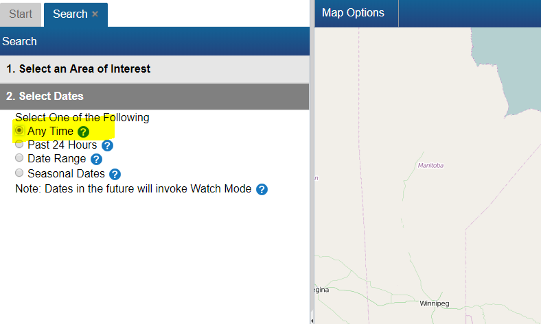
How do I narrow my search by time, dataset, and data options?[edit | edit source]
To narrow your search for a particular image:
- From the Start Page, start a new search by clicking, the "Search for Earth Observation Data and Aerial Photographs" link
- Next, click on "2. Select Dates". The default is "Any Time", but you can narrow to date range, seasonal dates, or last 24 hrs
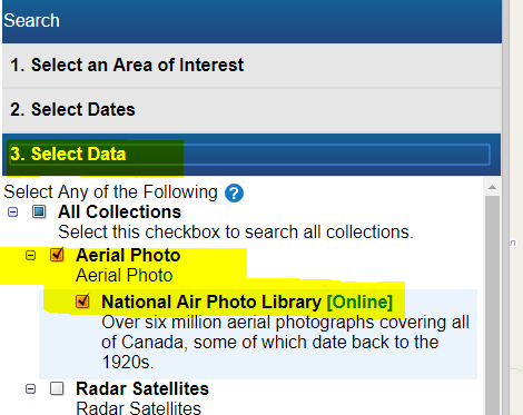
- Next, click on "3. Select Data" and select the dataset / collection of interest
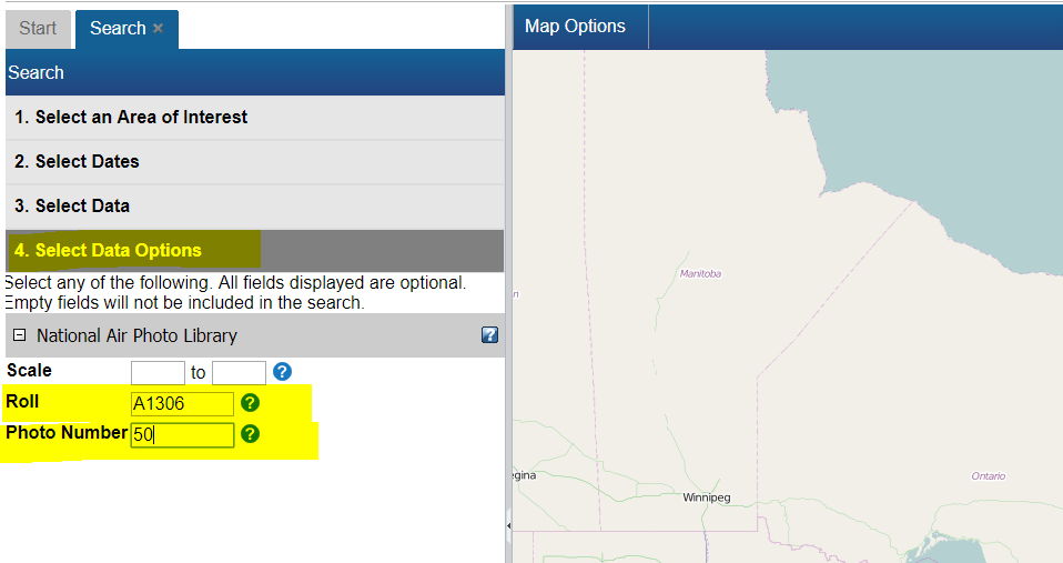
- Next, click on "4. Select Data Options" and enter particular data options specific to your dataset
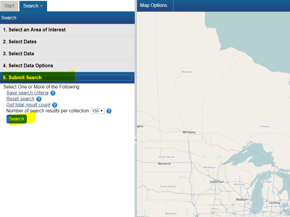
- Finally click on "5. Submit Search", then click the "Search Button"


How do I search for a particular National Air Photo Library Photo[edit | edit source]
To find a particular National Air Photo Library (NAPL) photo using Roll Number and/or Photo Number:
- From the Start Page, start a new search by clicking, the "Search for Earth Observation Data and Aerial Photographs" link
- Next, click on "2. Select Dates" and select "Any Time"
- Next, click on "3. Select Data" and select "National Area Photo Library"
- Next, click on "4. Select Data Options" and enter your Roll Number and/or Photo Number
- Finally click on "5. Submit Search", then click the "Search Button"
How do I search for data near a given city or area of interest?[edit | edit source]
To find data near a desired area e.g. a National Air Photo Library (NAPL) over Barry's Bay, ON, CA simply
- From the Start Page, start a new search by clicking, the "Search for Earth Observation Data and Aerial Photographs" link
- Next, click on the "1. Select an Area of Interest" Search Criteria grouping (grey header #1)
- Select the "Draw an Area" option
- Select a pink shape option e.g. the Rectangle.
- Next, go to the map on the right, and draw a shape around the area of interest.
- Notice how you area is reflected on the map in pink.
- Finally click the last Search criteria grouping "5. Submit Search", then click the "Search Button"

I did a search for data and I am not seeing any results?[edit | edit source]
The first thing to check is your search dates. By default, EODMS searches use "Past 24 Hours". If you are looking NAPL imagery (which dates back to 1920) you should select either "Any Time" or specify a specific Start and End Date

Working with Results[edit | edit source]
The Result screen's map view displays too many image footprints to make sense of[edit | edit source]

Answer
You can hide result thumbnails using the "View only selected footprints" menu option in the top left of the results screen.

There are so many columns, how do I hide some or show different ones?[edit | edit source]
- Position your mouse in any column header until a blue down-arrow appears. Click it
- Next click, Columns, which will open up the list of columns
- Hide and Show different columns by checking and unchecking

How do I see the details of an image (i.e. metadata)?[edit | edit source]
While the result columns show some information, full metadata information can by:
- Scrolling the results view to the right by using the horizontal scroll bar along the bottom
- Clicking the "View" link in the "Metadata" column.

Is it possible to export the results including geometry (i.e. spatial info)[edit | edit source]
- Above the results, click on the "Select Option" menu button
- Choose, "Save Search Results"
- Choose the desired format

How can I preview an image?[edit | edit source]
- Scroll to the right until you see the "Thumbnail" column.
- click the checkbox
- Observe the preview on the map.
- Note: In the case of NAPL aerial photos, you may see a place holder image. This usually means digitization has not been completed and the photo still resides on film only. You can contact NAPL directly to see if they can provide a preview:
Ordering[edit | edit source]
How do I order an image?[edit | edit source]
- With results loaded, check the "Order" checkbox
- Check the "Select item(s)" checkbox
- Finally, click the "Update Cart" button.
- Observe a new cart tab appears.

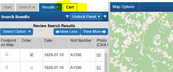
How do I order a National Air Photo Library Photo?[edit | edit source]
- Follow the steps to search for a particular NAPL photo above.
- With results loaded, check the "Order" checkbox
- Select your Media Type, File Format, Image Resolution, Level of Compression, check the "Select item(s)" checkbox and finally, click the "Update Cart" button. Note: If you would like a different Image Resolution than what is listed, you can specify later in another screen.
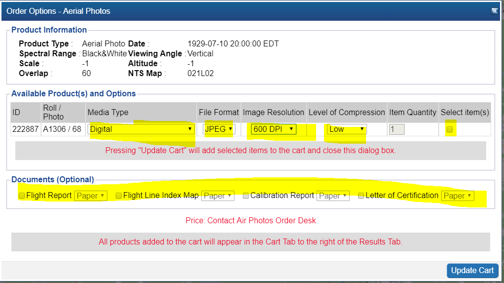
- Review your cart one last time and click "Submit Aerial Photo Order" Note: While pricing shown as N/A on EODMS, these images are not free and payment will be made directly with the NAPL order desk once they process your order. For complete list of pricing you can visit: https://www.nrcan.gc.ca/earth-sciences/geomatics/satellite-imagery-air-photos/air-photos/photo-collection/9707
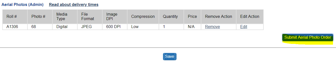
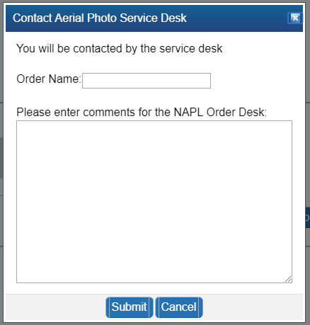
- Finally enter a name for your order and any additional comments, e.g. a custom image resolution, the reason you are making this purchase.
- Your order is now submitted to NAPL. Your cart will show as "SAVED" which is correct. You will also receive an email confirming receipt of your cart. Payment will be requested by the NAPL order desk my phone or email.


How do I know the prices of National Air Photo Library Photos[edit | edit source]
Full pricing on NAPL can always be found here: https://www.nrcan.gc.ca/earth-sciences/geomatics/satellite-imagery-air-photos/air-photos/photo-collection/9707
I received an email re: my NAPL order saying, "Your image request(s) (Order ID: 1234) have failed"[edit | edit source]
A failed email notification for an NAPL order can result if you attempted to use the "Reconfigure and Submit Order" menu option on an order which is already properly "SAVED". Doing this not necessary as submitting the order the first time correctly sends an email to the NAPL order desk for processing. An order marked as "SAVED" is correct and no further action is required on your part and you can ignore the failed notification.
If this is not the case, proceed to contact the EODMS support desk.
I am trying to order free RADARSAT-1 images, but when I click the order checkbox I am presented with Order Desk information[edit | edit source]
This message is presented to for the RADARSAT-1 *RAW* Catalog. YOu should instead re-do your search with selecting the "RADARSAT-1 Open Data Products [Online]" collection
When I try to order a CCRS Thematic Dataset, I get an error, "You are not permitted to add more than 25 items to your cart. Please select fewer items or narrow your search for Value-Added Satellite Products"[edit | edit source]
Because of the time-series nature of CCRS thematic datasets, the size of the product depends on how wide you chose your start and end time. For example, attempting to download the MODIS 10-day composite time series product for all time (e.g. start time 2016 - 2019) amounts to a 1.36 TB product. To reduce the size of your product to enable ordering, re-do your search with a more narrow time window e.g. Jan 01 2019 - Jan 17 2019 which amounts to a smaller 26 GB.
Now that I have submitted my aerial photo order, how long does the order desk production process take?[edit | edit source]
Ordering times can vary. You can always followup on the status on your order by contacting the NAPL order desk directly: https://www.nrcan.gc.ca/earth-sciences/geomatics/satellite-imagery-air-photos/air-photos/photo-collection/9707
Download[edit | edit source]
How do I download my order data[edit | edit source]
When your order is ready, you will receive an email from EODMS with the subject "EODMS Image Request Delivery Notification" that looks like the below. You can use a web browser to access the FTP and HTTP links or the FTP client software of your choice for the FTP. When using the direct links in the email, you will need to supply the same username and password that you use to log on to the EODMS site.
From: nrcan.eodms-sgdot.rncan@canada.ca <nrcan.eodms-sgdot.rncan@canada.ca>
Sent: October 29, 2018 07:46
To: user@canada.ca
Subject: EODMS Image Request Delivery Notification

Dear User,

Your image request(s) (Order ID: 123) have been processed and are now ready for download at the Earth Observation Data Management System (EODMS) FTP site.

The requested value-added satellite products under the account "user" can be found in:
FTP	FTP address: ftp://data.eodms-sgdot.nrcan-rncan.gc.ca
Directory: /public/carts/xxx-xxx-xxx-xxx-xxxx
Direct link: ftp://data.eodms-sgdot.nrcan-rncan.gc.ca/public/carts/xxx-xxx-xxx-xxx-xxxx

HTTPS	https://data.eodms-sgdot.nrcan-rncan.gc.ca/public/carts/xxx-xxx-xxx-xxx-xxxx


Query Information
Date range: 	2016-10-01 to 2016-12-31
Number of products: 	1
Total cart size: 	135.01MB
Request submission: 	2018-10-29 07:40:25 EDT
Delivery date: 	2018-10-29 07:46:02 EDT
Delivery status: 	delivery 1 of 1

Product Information
Product name: 	MODIS 10-day composite time series of Canada (Collection 5)
Delivery path: 	./canada_composite_modis_10day

Supplement file(s): 	README.pdf;LISEZMOI.pdf
Clipped to AOI: 	NO
Number of composites: 	9
Total product size: 	135.01MB
I received an email from an NMSO commercial satellite provider (CSP). How do I download my NMSO data (Government of Canada only)[edit | edit source]
Once an NMSO CSP delivers data to NRCan, a government employee can
- Do a simple search as per above: https://wiki.gccollab.ca/EODMS_FAQ#Searching
- For *download only* (data that EODMS cannot yet load e.g. PLEIADES) proceed directly to https://data.eodms-sgdot.nrcan-rncan.gc.ca/ and enter their EODMS username/password. After that the data can be found using the following convention: https://data.eodms-sgdot.nrcan-rncan.gc.ca/<department>/<satellite>/<sensor> (e.g. https://data.eodms-sgdot.nrcan-rncan.gc.ca/dfo/pleiades/pleiades)
I downloaded my image order. What software can I use to view the images?[edit | edit source]
QGIS[edit | edit source]
QGIS is a well-supported desktop GIS tool which supports a variety of GIS image formats. You can download QGIS for free from their website.

MapReady and Google Earth[edit | edit source]
Another method is to download MapReady from https://www.asf.alaska.edu/data-tools/mapready/.
open your product (.sarl file, for example), leave all the defaults and click, process file. Finally, click on the Google Earth icon to display it.


User Account Information[edit | edit source]
How do I register for an account?[edit | edit source]
Simply click on the Register (Required to order products) link on the EODMS start page.
I am receive an error, "Invalid Login" and I am sure am entering the correct username and password (or temporary password)[edit | edit source]
- Note*: Per security controls in EODMS, a user account will expire due to 2 years of website inactivity, or password not being changed after 5 years.
Please check:
- As your username is case sensitive, please ensure that you are entering all uppercase and lowercase correctly
- Your account may be disabled, despite entering correct username and password. Please contact EODMS support team (mailto:nrcan.eodms-sgdot.rncan@canada.ca) to have it reactivated.
How do I update my account information (e.g. email address, password)?[edit | edit source]
- Login to EODMS
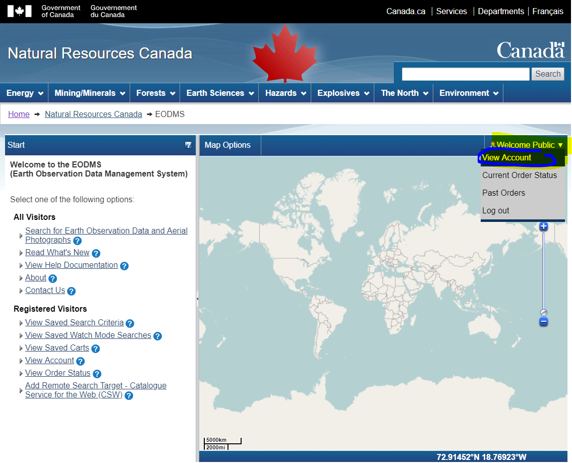
- At the top right of the map, Click on your username, then click Account Information:
- With the Account Information screen displayed, update any detail you wish, e.g. Email Address, First Name, Last Name, Department, etc.

- You can change your password by click on the "Account Information" tab and then the "(Change Password)" link


Can I change my username after my account has been created?[edit | edit source]
Unfortunately no. You can however create a new account and any special privilges will be transfered over.
I forgot my password, How do I retrieve it?[edit | edit source]
- Click the login link
- Fill in only your username into the username text box
- Finally, click the "Forgot your password?" link and say "OK" to the following message to have a temporary password emailed to you.
I forgot my username. How do I retrieve it?[edit | edit source]
You can contact the EODMS support team (mailto:nrcan.eodms-sgdot.rncan@canada.ca) and provide you first name, last name, and email address used to register the account and it will be provided by email.